
.
Petherwin Beds 1911 by Clement Reid ‘The geology of the country around Tavistock and Launceston.’
A strata that has yielded the peculiar Clymenia-fauna, though it is by no means certain that this is their correct stratigraphical position. The three or four square miles over which this Clymenia-fauna occurs are surrounded on three sides by Carboniferous rocks, and on the fourth, the connexion with the other Devonian slates is so obscure that we can say nothing as to its nature. We think that the balance of the evidence points to the Clymenia-beds being newer than the slates already described, newer than the volcanic series. But these last are entirely absent in the area around Petherwin, and we cannot say whether they have been cut out by one of the numerous thrusts and faults, whether they have died out, or whether they may not, after all, be higher than the Clymenia-beds. If, however, the Clymenia-beds are low in the series, we are confronted with the great difficulty that they are missing over so much of the coast where other fossiliferous zones occur. But if the Clymenia-beds are high up, their absence elsewhere is readily accounted for by an overlap or overthrust of Carboniferous rocks. The peculiar Petherwin fossils were nearly all obtained from three quarries in South Petherwin parish. Henry De la Beche, who seems to have discovered these fossils in 1832, gives no detailed account of the quarries in 1839; though he gives a preliminary list of the species determined by Phillips (Geological Report pp. 59,60); but John Phillips, who was employed to examine the fossils, notices the three quarries from which he, Holl, and Pattison obtained their specimens. The old quarries are now obscured (1911), as the limestone has not been worked for many years; it will, therefore, be necessary to refer to the published accounts. Phillips (Palaeozoic Fossils of Cornwall, Devon &c., 1841, p.195) speaks of the Petherwin Group as “a series of argillaceous, laminated beds, only partially subject to slaty cleavage, and enclosing concretionary balls, or more or less irregular bands and strata of limestone. The colour of the whole is light grey, or greenish. The shaly laminae above the principal mass of limestone are called the ‘head,’ and in this are found the greater number of the organic remains for which the group is remarkable. From some of the nodules of impure limestone, imperfectly burnt in the kiln, we obtained, Mr Pattison’s guidance, many Goniatites and Clymeniae by easy fracture; others are detected by the workmen who quarry and break the stone and remove the ‘head.’
“Three or more quarries are seen on this range of limestone, two of them now worked, on each side of the road from Launceston to Petherwin; the other, called Landlake, is a mile further down the little valley in which all the quarries lie. There is, or appears to be, at Landlake quarry, some unconformity between the black shaly beds, which are at the base of the carbonaceous group, and the grey calciferous rocks of the Petherwin group. These latter dip north 30° east; the former dip south 5° east. The line of valley is here the junction, a circumstance which diminishes the importance of the observation as a ground for inferring a real unconformity since it is a very common fact that along the lines of valleys the dips are locally deranged. There is, moreover, some appearance of minute reversal of the dip of the black shales at the part nearest the junction.”
Daniel Sharpe, in 1846 (Quarterly Journal Geol. Soc., vol. iii., 1847, p.77), selected South Petherwin as a favourable locality for the study of slaty cleavage and gave some additional particulars as to the geological structure. According to him; “The South Petherwin limestone quarries are worked upon the line of an anticlinal axis running nearly E. and W., but the beds dip at different angles on the opposite sides of the quarries, and there are also several minor faults. The planes of cleavage are also bent over in a flat arch, of which the axis running E. and W. coincides in direction with the axis of the beds, but the cleavage planes are less inclined than the beds. From these irregularities, the angle of incidence of the planes of bedding and cleavage varies in different parts, between 20° and 90°. The upper beds consist of rotten, grey, argillaceous slate, separated by thin beds of soft ochreous earth, crowded with organic remains too frail to bear removal, but whose forms may be seen on the spot. There are many fossils in the slates, especially near their junction with the ochreous beds. Below these are alternations of beds of limestone and slate containing fewer fossils. The beds of different mineral character have been differently affected by cleavage, which is most seen in the upper slates, and only affects the limestones slightly, but is hardly to be traced in the thin beds of ferruginous or ochreous earth. The distortion of the organic remains in each bed is in proportion to its cleavage; in the slates, they are extravagantly distorted, in the limestones slightly so; while in the soft ochreous beds, in which there is little cleavage, the fossils have preserved their form nearly unaltered. Although at present the loss of the calcareous matter of the shell has left these thin beds softer and more rotten than the others, it is possible that when they were full of shells they were better able to resist pressure than the other beds, which are now the hardest.”
Pattison, in 1859 (‘On the Petherwyn Beds,’ Trans. R. Geol. Soc. Cornwall, vol. vii., p.133.) adds further particulars: “At Petherwyn Water the upper rock is a thin green slate with glossy chocolate partings and ochreous layers of rotten fossiliferous limestone. The thin slate is continued downwards, becoming more coarse and hard, and is interstratified with about six layers of limestone varying from two inches to two feet in thickness, and occasionally forming bunches.” He also adds that: “At the present moment there is not a quarry in work on the whole line, though some have been wrought for upwards of a century (at West Petherwin), and others have been perseveringly continued for many years without profit.”
In 1868 Holl (Quart. Journ. Geol. Soc., vol. xxiv., 1868, p.416.) remarks with regard to the Landlake quarry that “it is from this spot that by far the larger part of the South Petherwin fossils have been obtained.” Holl, it must be remembered, in his youth had helped De la Beche and Phillips in this district, and had collected many of the fossils determined by Phillips. We cannot add much to the published description, but it will be useful to draw attention to the sections now visible, commencing on the west at Trewen, where the Petherwin limestones first make their appearance. The limestone was worked at Trenault for many years in long tunnels driven into the hillsides following the bands of lenticles. These tunnels are now full of water. The limestone is very brittle and cherty and of a pale lilac-grey colour. The associated slates are usually grey-green, and are, as a rule, spotted. The Trenault quarry shows Spirifer verneuili and crinoids.
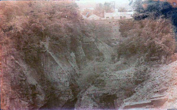
East of Trenault come two or three miles over which no limestone appears to have been worked, and the geology is much confused by overthrust masses, but pale-green calcareous slates full of fossils around and west of Botathan seem to belong to the same series. The fossils are obscure brachiopods, crinoids, fenestella, and a branched bryozoan(?). These greatly resemble the pale slates overlying the limestone at Landlake, and it is evident that limestone has been mined here also. This would give the normal Cornish east and west strike between Trewen and Landlake, the rocks passing undisturbed beneath overthrust masses of various ages having a north-west and south-east strike. A mile further to the east, in the valley a quarter of a mile north-west of the Church, we come to the West Petherwin Quarry, which it seems to be westernmost of the three quarries mentioned by Phillips; it lies about a quarter of a mile west of the high road from Launceston to South Petherwin. The deep quarry is now flooded, and most of the talus is overgrown, but certain parts were obviously very fossiliferous. A similar but smaller pit will be found on the east side of the same high road, south of Daws House, and this is probably Phillips’ second quarry, for a smaller quarry higher up the hill to the south-east seems only to have been worked for walling stone. Another small quarry is seen close to the north-western corner of Landlake Wood, and then we come to the well-known Landlake quarries, which lie in the valley half a mile north of Landlake. There are several quarries around Landlake Mill, but the two referred to by the early writers are those just above the Mill, on either side of the high road. The sunk quarry on the east side of the road is the limestone quarry alluded to as yielding most of the Petherwin fossils, and from the quarry, Mr Peter obtained many years ago the new trilobite (Proetus dunhevidensis) recently described by Dr Ivor Thomas (Geol. Mag., 1909, p. 197). This quarry is now almost filled up with the Launceston town refuse (1911).
On the west side of the road, and at a higher level, is a quarry still worked in a small way for walling stone. The rock is a greenish calcareous slate full of much-distorted fossils, but in most parts, it is much decalcified and oxydised. Actual limestone bands are not now to be seen in this quarry, and we cannot learn that any of the limestone was quarried here. The kiln at the entrance to this quarry was used, we are told, for burning stone from the lower pit. An abundance of Spirifer verneuili and Fenestella characterise the beds now being worked. A third quarry has more recently been opened close to the high road, a quarter of a mile further south. It is in beds of a quite different character, for below blue slate with spirifers and calcareous sandy shales there is seen a massive sandstone twenty feet thick, quarried for gate-posts. This ‘gate-post quarry’ shows other peculiarities, for the laminae of the sandy shales, are covered with small lamellibranchs of several species, interspersed with impression of Clymenia, etc. Sandy deposits of this character are quite unknown elsewhere in Cornwall, and it is unfortunate that the only part of the fossiliferous shales yet quarried into is so much weathered as to spoil the fossils. An earthy ferruginous seam associated with them appears to represent a decayed thin limestone. The exact relation of the sandstone to the limestone-beds in the quarry below cannot be made out, for dips are very irregular; but if, as seems probable, the sandy strata are the highest, we have here strata which almost immediately are overlapped by the overlying Culm Rocks. The gate-post quarry, when enlarged and deepened, may throw much light on the succession of the deposits. Sandy strata of this character ought also to yield a fauna more closely resembling that of the sandy North Devon type that that of the Petherwin limestones if in truth the Upper Devonian rocks of the two areas are contemporaneous.
The limestone bands seem to be cut off by a fault which separates Devonian from Carboniferous rocks east of Landlake; but some impure limestone is seen in the road-cutting at Larrick and again at Trewarlett, though workable limestone has apparently died out. The strike seems to curve southward so that around Trevozah Cross there are found in the roads some sandy and gritty bands like those of the gate-post quarry; they are associated with silvery micaceous shales.
Around Lezant we could only see greenish slates with crinoid ossicles, such as might occur either above or below the limestone series; but highly fossiliferous slates are again seen in a small overgrown quarry by the roadside half-mile south-east of Landue Mill. The section in the adjoining road-cutting is now overgrown, though it still yields fragments of highly fossiliferous slate spirifers. It has been taken to indicate an unconformity between Devonian and Culm, but on what grounds is not obvious, the illustration given by De la Beche (‘Geological Report,’ pp.61, 107 and fig. 12; see also Phillips, ‘Palaeozoic Fossils,’ p. 197.) clearly represents an overthrust fault such as forms the junction wherever we have been able properly to examine it. This point will again be referred to.
As the Petherwin Beds are lost beneath the Culm on the east it will be necessary to take next the Devonian inliers along our northern margin, for these represent either the Petherwin series or some horizon still higher in the sequence. The westernmost and best known of these inliers lies outside the Tavistock map, but must be included in this description on account of the light it throws on the northward extension of the Devonian rocks. In the valley of the Ottery (Attery), two or three miles above its junction with the Tamar, Devonian rocks reappear for a mile or two around Yeolmbridge and Underwood. The exposure on the south side of the river, near Underwood, shows hard grey-green platy slate, which has been worked in two quarries, now much overgrown. On the west of these beds pass under very hard blue-black slate, which may be either Devonian or Culm, but in which we could find no fossils. The undoubted Devonian slates exhibit a good deal of contortion, though they have yielded good flagstones. The fossils recorded are cf. Aulocstis entalophoroides (Schlüter), which occurs also at Heale; Sanguinolites ? ellipticus (Phillips), a South Petherwin form; and Phacops latifrons. On the east side of Underwood, the green slates pass under black gritty shales, which gradually sink to the river level.
Around Yeolmbridge the Devonian rocks occupy a larger area, mainly on the north side of the river, and they have been extensively worked for flagstones and slates in a deep quarry at the entrance to Werrington Park. The quarry is now abandoned and flooded, but the parts above the water-level show an enormous S-shaped fold in a hard, dark platy slate. The cleavage usually coincided with the horizontal bedding but cuts through the nose of the fold. The occurrence of this fold makes it probable that, notwithstanding the depth of the quarry, most of the slate belongs to one thin bed. No fossils could be found in place, but on the extensive spoil heaps are scattered a few fossiliferous nodules, apparently all coming from a single seam now below the water level. Fragments of trilobites are abundant in some of the nodules. Towards the west end of this exposure, the grey slates give place to micaceous silty slate. A small pit on the south side of the river is in hard grey slate. Immediately above the Devonian slate at Yeolmbridge come black Culm shales and grits, which last develops into a massive crag of grit on the east. The succession seems to be quite different from that at Underwood, and everything suggests the occurrence of a nearly horizontal thrust-fault, driving Carboniferous rocks for a long distance over Devonian. The marine lower beds of the Culm seem to be out, as well as an unknown thickness of Devonian rocks.
Visits: 57